10 Things You Can’t Miss in Big Sur, California

Imagine a place where jagged cliffs plunge straight into sapphire-blue Pacific swells, where redwood groves perfume the air with earthy sweetness, and Highway 1 twists like a ribbon between sea-spray and sky. That place is Big Sur—an untamed, 90-mile stretch of California’s central coast that feels equal parts road-trip legend and raw wilderness sanctuary. In the pages ahead, I’ll walk you through the 10 Things You Can’t Miss in Big Sur California, from waterfall-draped coves that look ripped from a postcard to secret skyline drives that locals whisper about over campfires. Whether you’re planning a whirlwind weekend or a slow-motion sabbatical, consider this your personal field guide: packed with practical tips, storytelling flair, and a nudge (or three) to roll down the windows, breathe in the salty-redwood aroma, and let Big Sur transform your sense of what a coastal escape can be. Ready to chase sunsets and purple sands? Let’s dive in.

1. Bixby Creek Bridge – The Postcard View
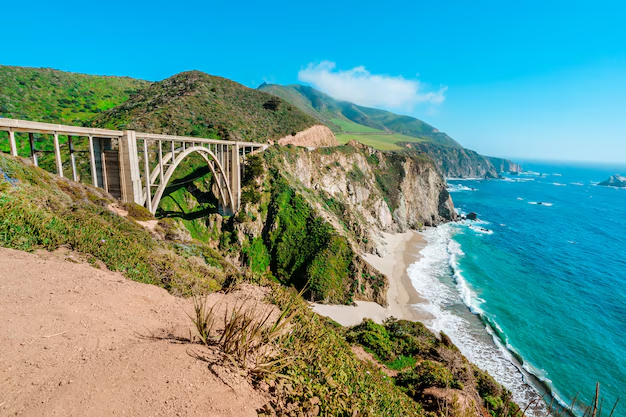
Why This Arch Captivates at First Sight
Few man-made landmarks feel as organic to the landscape as Bixby Creek Bridge. Completed in 1932 and soaring 260 ft (79 m) above the canyon floor, its elegant reinforced-concrete arch gracefully frames both rugged cliffs and restless Pacific surf. Travel magazines love it for the same reason motorists do: one glance and you instantly know you’re on Highway 1 in Big Sur.
Breathe in the salty breeze scented with coastal sage, listen for the faint echo of waves ricocheting through the arch, and you’ll appreciate why this spot routinely tops lists of “10 Things You Can’t Miss in Big Sur California.”
Best Pull-Outs & Golden-Hour Photo Angles
- North-Side Turnout (Highway 1, mile marker 59.8): Classic wide shot with the bridge framed by turquoise coves. Arrive 30 minutes before sunset for honey-gold light on the concrete.
- Castle Rock Viewpoint: A short scramble uphill on the north side rewards you with a higher, less-crowded vantage — perfect for drones (where permitted).
- Old Coast Road: This gravel detour snakes above the bridge for sweeping panoramas; AWD recommended after rain.
- Blue-Hour Bonus: Stay 15 min past sunset; the arch glows pastel pink while tail-lights streak along the deck.
Quick Safety + Parking Tips
Recent crowd surges have led Monterey County to enforce a no-parking zone immediately next to the bridge; rangers fine vehicles stopped in the roadway. Instead, use the gravel lots 0.2 mi north or the signed pull-out south of the span, then walk the shoulder with care.
Smart Traveler Checklist
| Tip | Why It Matters |
|---|---|
| Arrive at dawn or weekday off-season | Fewer cars, soft light, dolphin sightings |
| Bring a windbreaker | Coastal gusts can exceed 25 mph even in July |
| Pack out all trash | Steep cliffs make cleanup nearly impossible |
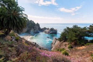
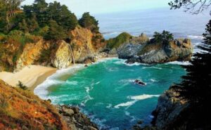
2. McWay Falls – An 80-Foot Plunge into Turquoise Surf
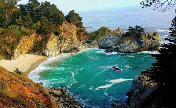
The Story Behind the “Impossible” Beach
Imagine a silver ribbon of water leaping off a weather-worn granite bluff, falling straight onto a tiny crescent of sand that no human foot may ever touch. McWay Falls is one of just two waterfall “tide falls” in all of California, and the only one framed by cinnamon-colored cliffs and teal surf so vivid it looks digitally enhanced. Once the private ranch land of homesteader Julia Pfeiffer Burns, the cove is now permanently protected—no staircases, no rope descents, nothing but untamed beauty. Stand at the overlook and you’ll catch the mingled aromas of salt spray and sun-toasted chaparral; listen closely and you’ll hear eucalyptus leaves rustling above the muffled thunder of waves.
Easy Overlook Trail & Accessibility
| Detail | Quick Facts |
|---|---|
| Trail length | 0.6 mi / 1 km round-trip, flat gravel |
| Trailhead | Parking lot on the east side of Hwy 1, Julia Pfeiffer Burns State Park |
| Wheel-friendly | First 0.25 mi paved; benches every ~250 ft |
| Best light | One hour before sunset (golden cliffs) or just after sunrise (soft pastels) |
Route: From the lot, walk through the pedestrian tunnel under Highway 1, turn right at the sign for Waterfall Overlook, and follow the bluff-top path until the guardrail delivers that gasp-worthy reveal.
Leave-No-Trace for Fragile Cliffs
Resist the urge to scramble down—the slopes are crumbly sandstone, and even a single bootprint accelerates erosion. Keep to the boardwalk, pack every crumb back to your car, and remember that preserving this postcard scene is part of the adventure.
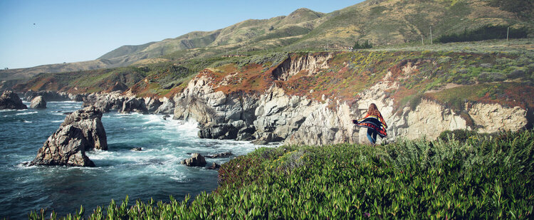
3. Pfeiffer Beach – Purple Sand & Keyhole-Arch Sunsets
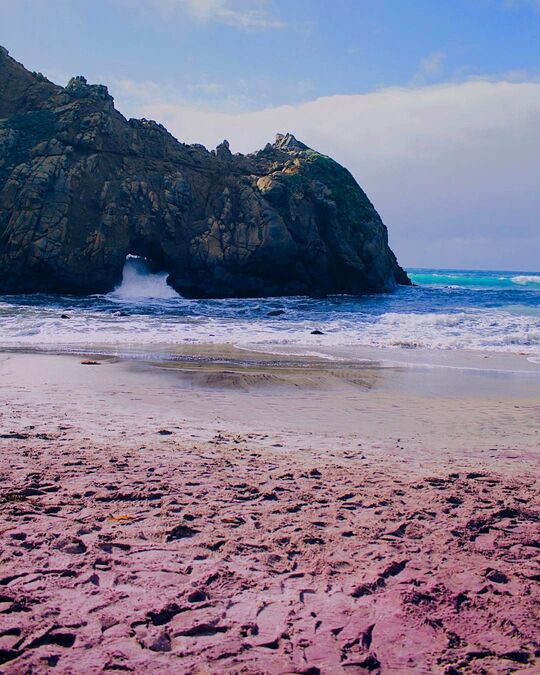
What Gives the Sand Its Lavender Hue
Beneath your feet, streaks of amethyst ribbon through caramel grains—nature’s own tie-dye. The color comes from manganese garnet eroded out of the surrounding hillsides and washed downstream every winter. After a storm, the beach looks like an artist dragged a giant paintbrush across the shore. Kick off your shoes, run your fingers through the violet speckles, and you’ll feel the mineral grit that makes Pfeiffer Beach one-of-a-kind along the 10 Things You Can’t Miss in Big Sur California checklist.
Timing the Keyhole Light-Beam Phenomenon
Once a year—in the weeks around the winter solstice—the setting sun lines up perfectly with the sea-carved “Keyhole Arch,” blasting a molten beam of light through the granite portal onto the wet sand. Photographers queue hours in advance, tripods at the ready. Miss the solstice window? Sunset still dazzles: foamy waves burst through the arch like a natural fireworks show, tinging spray gold and rose. Arrive 90 minutes before sundown, stake a spot left of center, and keep an eye on incoming tides—rogue waves love expensive camera gear.
Fees, Facilities & Hidden Parking Lot
| Need-to-Know | Details |
|---|---|
| Access road | Sycamore Canyon Rd. (unmarked turnoff mile marker 45.64). Narrow, two-way—yield to oncoming traffic. |
| Parking fee | $12 per vehicle, cash preferred (lot fills by 11 a.m. on weekends). |
| Restrooms | Basic vault toilets near the lot—bring hand sanitizer. |
| Services | No cell signal, no food vendors; pack snacks and plenty of water. |
Safety & Leave-No-Trace Checklist
- Sneaker waves: Keep at least 30 ft/10 m back from the waterline, especially at high tide.
- Driftwood fires: Banned—swing by Pfeiffer Big Sur State Park’s campground if you crave a legal campfire glow.
- Sand souvenirs: Tempting, but removing colored sand depletes the fragile layer; let your photos do the collecting.
Sensory Snapshot
- Sight: Lavender ripples glowing under peach-orange sunsets.
- Sound: Pacific rollers thundering through the arch, punctuated by gull cries.
- Smell: Salty kelp mingled with sun-warmed coastal sage.
- Touch: Cool, slightly gritty sand that sticks to bare feet like pixie dust.
Quick-Hit Planning Tips
- Bring a wind shell—cliff-funneled gusts can whip sand into mini sandstorms by afternoon.
- Visit mid-week mornings for tranquil tide pools and fewer footprints.
- Pack a wide-angle lens (16–35 mm) to capture both arch and sky in one frame.
4. Julia Pfeiffer Burns State Park – Redwoods Kiss the Ocean

Must-Do Trails: From Fern-Filled Canyons to Skyline Ridges
| Trail | Distance & Difficulty | Why You’ll Love It |
|---|---|---|
| Ewoldsen Loop | 4.5 mi / 7.2 km, moderate | Meanders through cathedral-tall redwoods, then climbs to eagle-eye bluffs where sea meets sky. Bring layers—the micro-climates shift from misty canyon cool to sun-splashed ridge warmth. |
| Canyon Falls Spur | 0.25 mi / 0.4 km, easy | A quick detour off the Ewoldsen that rewards you with a moss-draped waterfall and the earthy perfume of bay laurel. Perfect leg-stretcher if Hwy 1 traffic has you antsy. |
| Partington Cove Trail | 1 mi / 1.6 km, easy-moderate | Follows an old logging road through a hand-hewn tunnel to a secret cove once used by smugglers—listen for waves thundering under the footbridge. |
Pro Tip: Start the Ewoldsen clockwise; you’ll tackle the steepest grade first and greet mid-morning light filtering like liquid gold through the redwoods.
Wildlife Encounters You Might Hear Before You See
- Western Screech-Owls hooting at dusk—an eerie, bouncing ping-pong call.
- Steller’s Jays swooping overhead, flashing cobalt wings as they beg for crumbs (don’t oblige).
- Gray whales spouting offshore from December to April; scan the horizon from the Overlook bench.
- Banana slugs sliding across redwood duff—an icon of coastal damp forests.
Keep your senses tuned: the forest often announces its residents with rustles, calls, and ocean echoes long before they appear.
Picnic Spots with Redwood Aromatherapy
- Canyon View Bench – halfway up the Ewoldsen, shaded by soaring trunks; unwrap a sandwich while the creek chatters below.
- Ocean Overlook Knoll – tiny clearing near mile 2.9; salty wind mixes with sweet redwood sap for Big Sur’s signature scent bouquet.
- Partington Cove Pebble Beach – flat stones perfect for portable chairs; sip coffee as turquoise swells surge against black basalt walls.
Remember to pack out every crumb—the park’s resident raccoons have PhDs in unattended-bag raids.
Quick-Hit Planning Guide
| Need-to-Know | Details |
|---|---|
| Parking | Small lot on the inland side of Hwy 1 (fills by 9 a.m. summer weekends). Fee $10 per vehicle. |
| Facilities | Vault toilets at trailheads; no potable water—bring at least 2 L per hiker. |
| Cell Service | Spotty to non-existent; download offline maps. |
| Best Light | Early morning for sun-shafts in redwood groves; golden hour for cliffside glow. |
5. Point Lobos State Natural Reserve – Monterey’s Wild South Gate
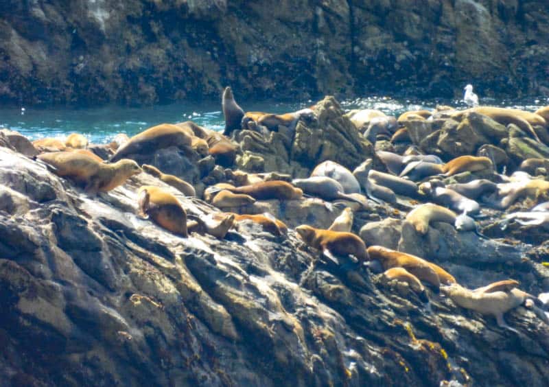
Barking Sea Lions & Wind-Twisted Cypress
Step onto the South Shore Trail and the soundtrack changes from distant highway hum to the guttural ark-ark-ark of California sea lions sprawled across wave-splashed rocks. Above them, ancient Monterey cypress—gnarled by salt wind into living bonsai—frame coves as clear as blown glass. Pause at Sea Lion Point: every breath tastes of brine and kelp, every exhale fogs in the cool Pacific draft. Keep binoculars handy; harbor seals pup here in spring and otters raft in the kelp year-round, cracking urchins like stone-age gourmets.
Snorkeling & Kelp-Forest Diving Basics
| Gear Checklist | Why It Matters |
|---|---|
| 7 mm wetsuit + hood | Water hovers around 55 °F / 13 °C even in August. |
| Low-volume mask & snorkel | Kelp fronds tangle less with streamlined kit. |
| Bright surface marker buoy | Boat traffic from Whalers Cove launch. |
| Reef-safe sunscreen | Preserve the plankton that feeds the entire food chain. |
Entry Point: Whalers Cove boat ramp (reservation required—book online as spots sell out weeks ahead). Slip beneath the surface and you’re in a cathedral of giant kelp, sunlight spearing green columns while orange Garibaldi patrol the aisles. Visibility can hit 40 ft / 12 m on calm winter mornings—surreal, weightless forest bathing.
Crowd-Beating Sunrise Strategy
- Arrive by 7:30 a.m.: Ranger kiosk opens then; first twenty cars often have cypress groves to themselves for an hour.
- Start with the Cypress Grove Trail: clockwise loop catches low-angle light igniting orange lichen on the trunks—photographers’ secret.
- Pack a thermos breakfast: picnic tables at Piney Woods are usually empty until mid-morning; sip coffee while pelicans skim the swell like syncopated metronomes.
Sensory Snapshot
- Sight: Turquoise coves scalloped by ivory foam, framed by emerald cypress.
- Sound: Sea-lion chorus layered over the distant boom of surf in granite grottoes.
- Smell: Peppery coastal sage laced with iodine-rich kelp.
- Touch: Cool marine mist settling on sun-warmed skin as trails shift from forest shade to cliff-edge glare.
Quick-Plan Cheat Sheet
| Need-to-Know | Details |
|---|---|
| Entrance Fee | $10 per car (covers all California State Parks same day). |
| Parking | Two small lots—fill by 9 a.m. on weekends; overflow closed when capacity reached. |
| Cell Service | Virtually none—download offline maps & tide tables. |
| Facilities | Flush toilets at Piney Woods; no food vendors—bring lunch & refillable water bottle. |
6. Pfeiffer Big Sur Campground & River – Forest Bathing 101
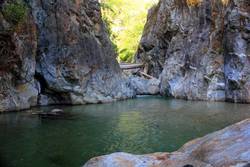
Best Swimming Holes & Tub-Temperature Pools
Just a half-mile upstream from the main campsites, the Big Sur River Gorge fans out into jade-green pools hemmed by granite. Here the water slows, warms to the mid-60s °F on summer afternoons, and invites everything from lazy floating to boulder-jump cannonballs. Local tradition says to park in Day-Use Lot 3, follow the unmarked footpath, then hop-scotch river stones until the canyon walls close in—a natural spa with redwood canopies for shade. Rock-hopping shoes save your toes, and a dry bag keeps phones splash-proof. The scene is so beloved it regularly tops visitor polls of Big Sur’s best swims.
River-Smart Tip: Flow surges after winter storms; if the current looks pushy, admire from shore and plan a spring return.
Campfire Scents, Stars & Storytelling
When daytime chirps fade to cricket hum, Pfeiffer’s 194 sites glow with ember-orange halos. Crackling madrone logs toss sweet spice into the night air while the river murmurs like background meditation audio. Lean back—no streetlamps here—and watch the Milky Way spill over redwood crowns. Kids toast marshmallows; seasoned campers spin yarns of Highway 1’s bygone landslides. Rangers often host weekend campfire talks on condor recovery or redwood ecology, wrapping up by 9 p.m. so the forest can reclaim its hush.
| Nightly Ritual | What Makes It Magical |
|---|---|
| “River lullaby” campsites (loops A–C) | Your tent door opens to glassy water and frog choruses. |
| Token showers | Five-minute bursts of hot water feel heavenly after a dusty hike. |
| Glen Oaks bakery run | Five minutes north: grab next-morning croissants, return before sunrise alpenglow. |
Reservation Hacks + Fire-Safety Rules
- Food lockers mandatory: Raccoons here unclip zippers like pros—stash everything fragrant, even toothpaste.
- Book six months out: Sites drop at 8 a.m. PT on ReserveCalifornia exactly 180 days ahead and vanish within minutes.
- Know your price tiers: Standard pads start at $35/night; riverfront premiums hit $50—worth every rippling lullaby.
- Tent-only vs. RV loops: No hookups, but rigs up to 27 ft fit in loops D & E; generators banned after 8 p.m.
- Burn bans: From late summer until first heavy rains, wood fires may pause; pack a propane stove as backup.
7. Garrapata State Park – Cliff-Top Wildflowers & Hidden Coves
Spring Bloom Calendar (January – May)
From late winter drizzle to early-summer sunshine, Garrapata’s bluffs ignite in technicolor. Carpets of pink seaside daisies, goldfields, and scarlet Indian paintbrush roll toward an aquamarine horizon like nature’s confetti. Aim for:
| Month | Floral Headliners | What to Expect |
|---|---|---|
| January – February | Coastal sage & early lupine | Crisp air, emerald hills, fewer hikers |
| March | California poppy burst | Hummingbirds hover at shoulder height |
| April | Peak paintbrush + purple owl’s clover | Slopes look hand-painted at sunset |
| May | Seaside daisies linger | Wildflower mix fades into summer gold |
Pack a macro lens or smartphone portrait mode—the bloom is selfie-approved yet delicate, so stick to marked trails to preserve the palette.
Soberanes Point Loop Map in 60 Seconds
- Trailhead: Gate 8 pull-out on Highway 1 (look for the cattle guard).
- Distance & Grade: 2 mi / 3.2 km lollipop, moderate climbs with cliff-edge exposure.
- Route Highlights:
- Coastal Meadow: Instant wildflower immersion with ocean roar below.
- Whale Peak Spur: 360° pano—Santa Lucia peaks inland, Pacific to infinity.
- Secluded Cove Overlook: Watch turquoise waves drill sea caves while cormorants draft the updrafts.
- Time Budget: 1–1.5 hrs with photos; double if you picnic.
Download an offline map before you go—no cell bars, just crashing surf and gull chatter.
Safety Brief: Sneaker Waves & Poison Oak
Big Sur’s beauty hides a mischievous streak.
- Sneaker waves: Keep at least 30 ft / 10 m from the water-line; never turn your back on the swell.
- Poison oak: “Leaves of three, let it be.” Wear long sleeves in spring—plants mingle with wildflowers along narrow paths.
- Steep drop-offs: Stick to the inland side of cliff trails when meeting other hikers.
Essentials Checklist
- Biodegradable bag for snack wrappers—leave the bloom as you found it.
- Lightweight wind shell (coastal gusts can whip sand into your lunch).
- 1 L water per person—no facilities.
- Small first-aid pouch with tech gear wipes; salt spray coats everything.
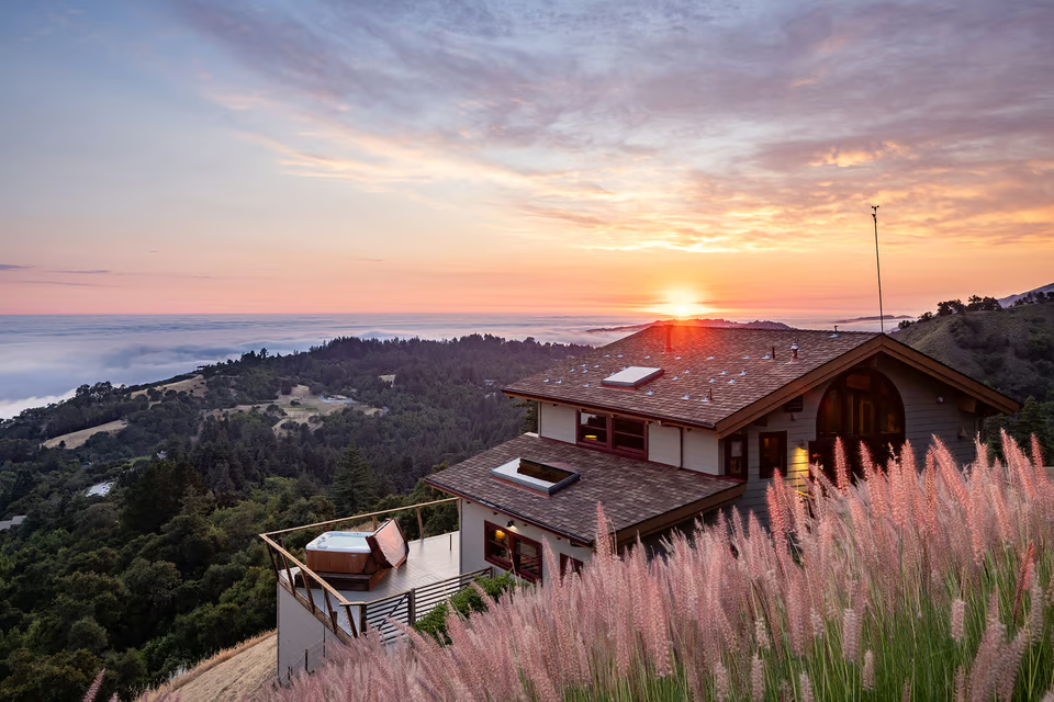
8. Nepenthe Restaurant & Phoenix Shop – Dining Above the Clouds
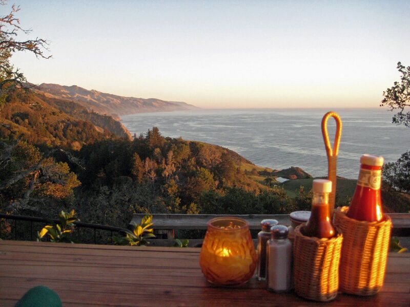
Bohemian Backstory: From Cabin to Celebrity Hangout
Perched 800 feet above the Pacific, Nepenthe began life as a red-roofed cabin bought in 1947 by Bill and Lolly Fassett from none other than Orson Welles and Rita Hayworth. The Fassetts swapped Hollywood glitter for Big Sur grit, hand-building terraced decks of native stone and redwood. By the 1960s the place had morphed into a magnet for beat poets, musicians, and barefoot travelers chasing salt-breezed freedom. Today the vibe remains gloriously laid-back: driftwood railings, rainbow-striped umbrellas, and panoramic views that steal words mid-sentence.
What to Order: Ambrosia Burger & Famous Fog Catcher
| Dish / Drink | Why It’s a Must-Try |
|---|---|
| Ambrosia Burger | A juicy patty on a French roll, slathered with red-pepper sauce that locals guard like family heirlooms. |
| Sauteed Calamari | Caught off Monterey Bay, flash-seared with garlic and white wine—tastes like sea foam turned into tapas. |
| Lolly’s Roast Chicken | Herb-rubbed comfort served with mashed potatoes that channel campfire coziness. |
| “Fog Catcher” Cocktail | Gin, elderflower, and fresh citrus; somehow mirrors the evening mist rolling up the canyon. |
| Phoenix Shop Lemon Bar | For dessert wander downstairs and grab this zesty square—perfect road-trip sugar jolt. |
Diet hacks: Vegetarian? Swap the burger for the Portobello “Ambrosia.” Gluten-free buns available on request.
Sunset Queue Survival Guide + Nearby Alternatives
- Arrive by 4 p.m. in summer; pager waits stretch to 90 minutes by golden hour.
- Grab a cappuccino from Café Kevah (same complex, one level down) while you wait—deck seating offers nearly identical views.
- Rainy-day detour: If fog socks in, drive two miles south to Sierra Mar at Post Ranch Inn for an indoor glass-walled panorama.
- Off-season hack: November weekdays mean walk-straight-in bliss and crimson sunsets reflected off storm-polished seas.
Quick-Plan Cheat Sheet
| Need-to-Know | Details |
|---|---|
| Location | 48510 Hwy 1, ~30 min south of Carmel |
| Hours | 11:30 a.m. – 10 p.m.; closed Thanksgiving & Christmas |
| Parking | Free but tight; additional pullouts along Hwy 1 northbound |
| Dress Code | Come as you are—hoodie and sandals welcome; bring a windbreaker for deck dining |
| Accessibility | Ramp to lower café and shop; main deck reached via gentle stairway |
9. Henry Miller Memorial Library – Culture Beneath the Redwoods
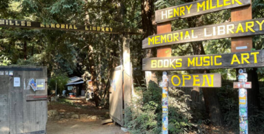
Literary Finds, Vinyl Vibes & Pop-Up Concerts
Step through the unassuming wooden gate and you’re swallowed by a living cathedral of coast redwoods. Inside the tiny clapboard house, shelves heave with first-edition Henry Miller novels, dog-eared travelogues, and local zines smelling faintly of cedar. A vintage turntable spins jazz or folk, its crackle mingling with bird song. Out back, a fairy-lit redwood amphitheater hosts everything from indie films to secret sets by chart-topping bands; the acoustics feel naturally engineered, the needles overhead muting highway noise to a whisper. On quiet afternoons you may find the caretaker reading aloud or a traveler plucking an old acoustic guitar – the line between visitor and performer blurs delightfully.
Hammock Siestas with Espresso Aromas
Scattered through the grove are rainbow-striped hammocks—first come, first sway. Grab a locally roasted pour-over from the makeshift espresso bar (cash jar for donations), sink into the fabric, and let filtered sunlight paint moving mosaics across your pages. The air tastes of espresso crema, redwood sap, and ocean mist drifting up the canyon. Time dissolves; phones stay pocketed because there’s no signal anyway. If inspiration strikes, borrow a battered typewriter and tap out a postcard poem—plenty of travelers do.
How Your Donation Keeps Big Sur’s Creative Heart Beating
The library is a 501(c)(3) non-profit run on shoe-string passion. Your suggested $10 entry donation keeps lights on, vinyl spinning, and free community events alive. A few extra dollars buys clean water for the rustic restrooms and helps fund scholarships for local art students. Drop bills in the weathered wine barrel by the door or pick up a screen-printed poster—souvenir money well spent. Every penny loops back into Big Sur’s artistic ecosystem, making this stop not just enjoyable but meaningful.
Quick-Plan Cheat Sheet
| Need-to-Know | Details |
|---|---|
| Hours | Daily 11 a.m.–5 p.m.; closed heavy-rain days |
| Parking | Gravel pull-out fits ~12 cars; arrive before noon in summer |
| Events | Concerts & film series May–Oct; tickets online or at gate (sell out fast) |
| Wi-Fi / Cell | None—embrace the digital detox |
| Kid-Friendly? | Yes; outdoor art table and giant Jenga keep little dreamers busy |
| Accessibility | Flat dirt paths; small ramp into main cabin |
10. Coast Ridge Road – Big Sur’s Secret Skyline Drive
Access Points & Vehicle Requirements
Hidden in the folds of the Santa Lucia Range, Coast Ridge Road begins just south of the Kirk Creek Campground turn-off and climbs more than 3,000 ft (915 m) in the first eight miles. A rusty Forest Service gate marks the start; once it’s open you’re on a single-lane dirt track sliced into chaparral slopes. In dry season, most crossover SUVs handle the ruts just fine, but after winter storms you’ll want true high-clearance AWD—mudholes swallow city sedans whole. Trailers are a hard no, and rental contracts rarely cover this adventure, so check the fine print before you sign.
- Mile 0.0 – Gate / Hwy 1 pull-out: Air down tires a smidge for traction, snap a “before” photo.
- Mile 5.4 – Tin House junction: Abandoned WWII lookout; short hike for north-coast panoramas.
- Mile 10.1 – Prewitt Ridge camp spur: Widest ridgepoint; drop-offs on both sides give sunrise over mountains, sunset over sea.
360° Vista Stops: Pacific Bluffs vs. Santa Lucia Peaks
| Vista | Elev. (ft) | Facing | Why Stop |
|---|---|---|---|
| Twin Peaks Turnout | 2,800 | West | Fog rivers spilling into Big Sur Valley; dolphins often visible in calm seas. |
| Cone Peak Backdrop | 3,200 | East | Sheer granite summit rising above redwood cloaks—highest coastal mountain in the lower 48. |
| Prewitt Ridge Meadow | 3,550 | Both | Campsites on a grassy ledge; watch sun burnish ocean to molten copper, then pivot to alpenglow-pink peaks. |
Bring a wide-angle lens; you’ll want to capture Pacific blue colliding with mountain green in a single frame.
Drone Etiquette & “Pack-It-Out” Reminder
The ridgeline screams launch me, but Coast Ridge Road sits within Los Padres National Forest where drones are legal only outside fire-closure zones and wildlife buffers. Keep flights below 400 ft, avoid condor thermals, and silence the beeps—nothing ruins ridge tranquility faster than a mechanical whine. Everything you haul up—coffee cups, orange peels, even biodegradable tissues—must come back down. There are zero trash cans, and gusts can loft litter straight into condor habitat.
Quick-Plan Cheat Sheet
| Need-to-Know | Details |
|---|---|
| Distance / Time | 14 mi (22 km) to Nacimiento-Fergusson junction; allow 1.5 hrs each way with photo stops |
| Season | May-Oct best; winter gates often closed by mudslides or fire risk |
| Services | None—pack 2 gal (8 L) water, full fuel tank, paper map |
| Cell Signal | Intermittent; SOS texts may send from ridge crests |
| Camping | Dispersed, first-come; use existing fire rings & check daily burn bans |